|
| Port city Chittagong. |
Located between the Chittagong Hill Tracts and the Bay of Bengal, Chittagong is a major commercial and industrial center as much of Bangladesh's export and import passes through the Port of Chittagong. The port has extensive facilities which are undergoing further development as Bangladesh prepares to serve as a transit country between North East India, Nepal, Bhutan, Southwest China and parts of Burma. According to a report released by International Institute for Environment and Development, Chittagong is among the ten fastest growing cities in the world.[8] Much of the city is surrounded by hilly terrains, and is experiencing rapid urban growth along with increased congestion.
 During the early 17th centuries the city was called by the Portugese by the name Port Grande then a part of the Arakan Kingdom, before falling under Mughal rule in 1666. It was later renamed by the Mughals as Islamabad. In 1930, Bengali revolutionaries led by Surya Sen launched the Chittagong uprising against the British Raj, during which British armories, telegraph and telephone offices in the city were attacked and hundreds of Europeans were assassinated in the Chittagong Club. During the Burma Campaign of the Second World War, Chittagong's port served as a major supply line for Allied forces while its airport was a major station for US Air Force combat aircraft. After the Partition of India, the city became a part of East Pakistan. During the Bangladesh Liberation War, Chittagong witnessed some of the heaviest fighting with the Mukti Bahini attacking Pakistani navy ships and the Indian navy firing missiles at Pakistani naval installations. It was in Chittagong where Awami League leader M A Hannan and liberation war hero and future Bangladeshi president Ziaur Rahman famously announced the declaration of independence of the country on behalf of independence leader Sheikh Mujibur Rahman. Chittagong was also where the assassination of President Ziaur Rahman had taken place during a failed mutiny in 1981.
* tourist attractions& tour spot in chittagong.
The city of Chittagong is a major tourist attraction in Bangladesh. Its green hills and forests, its broad sandy beaches and its fine cool climate always attract the holiday-markers. Described by the Chinese traveler poet, Huen Tsang (7th century AD) as "a sleeping beauty emerging from mists and water" and given the title of "Porto Grande" by the 16th century Portuguese seafarers. Chittagong is filled with dense green forests, endless rolling hills, a moderate climate and breathtaking beaches. Since the 7th century, Chittagong has been mentioned in many documents as a seaport of mystical beauty and magnificent charm. The bustling harbor stands in stark contrast to the tranquility and peaceful surroundings of the city.
# Chittagong Hill Tracts.
The Chittagong Hill Tracts (CHT) comprising an area of 13,180 km2 in south-eastern Bangladesh, is the only hill intensive area of Bangladesh. CHT consisting Rangamati, Khagrachari and Bandarban districts is home to country's largest concentration of at least 11 different ethnic groups and is a unique part of the country both in terms of landscape and its people.The ethnic groups are bound together by a shared history, years of peaceful cohabitation, and a common future. They differ from the majority Bengali population of Bangladesh in their physical features, culture and religion. However, nearly all the indigenous peoples also include traditional indigenous elements in their formal religious beliefs and practices.
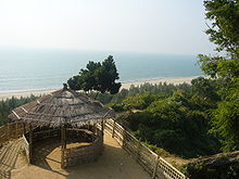
# Patenga beach.
# Foy's Lake.
Foy's Lake is a human-made lake in Chittagong, Bangladesh. The lake was once just a lake and spillway constructed by Assam-Bengal Railway engineer. It was dug in 1924 and was named after the English engineer Mr. Foy.[citation needed] The lake is next to Batali Hill, the highest hill in Chittagong Metropolitan area. An amusement park, managed by the Concord group, is located here which features usual theme park rides and attractions as well as boat rides on the lake, landscaping, restaurants, concerts with floating stages, scenic walking trails and many other fun activities. The park includes a water theme park, resort and an amusement center. The Chittagong Zoo is next door. Chittagong is known as the land of saints, darwishes and fakirs. Several mosques and shrines bear testimony to their presence in the city.
# Heritage Park.
 There is a heritage park called Shaheed Zia Memorial Complex and Mini Bangladesh at Chandgaon which reflects the most notable structures and instances of Bangladesh. This 71-metre tower in Mini Bangladesh in Chittagong has a restaurant on the top that rotates once every 90 minutes.The museum includes a revolving restaurant. One can perceive of the country's architectural beauty, ethnic traditions and archaeological inheritance through having a glimpse of the heritage park. Replica of major structures of the country, includes Jatiya Sangsad Bhaban (parliament building), National Memorial of Savar, Ahsan Manzil, Curzon Hall of Dhaka University, Paharpur Monastery, Kantajew Temple of Dinajpur, Lalbagh Fort and Sona Masjid. The park also has different rides for children.
# Chittagong Ethnological Museum.
 The Chittagong Ethnological Museum, country’s lone ethnological museum, offers the visitors the chance to acquaint with the lifestyles and heritage of various ethnic groups of the country. It was established in 1965. The museum authorities had collected rare elements used in everyday lives of different ethnic groups, of which some had already become extinct while some were on the verge of extinction. The museum contains four galleries and a small hall. Three galleries of the museum feature diverse elements of 25 ethnic groups, including Chakma, Marma, Tongsinga, Khumi, Murang, Sautal, Garo, Chak, Monipuri, Palia, Tipra, Hajang, Lusai, Shimuji, and Bom while the rest gallery displays the lifestyles of some racial groups of India, Pakistan, and Australia.[30] The sculptures of the people of different ethnic communities and a piece of broken Berlin Wall draw the visitors especially the children who can get impression of different festivals, livelihoods, and cultures of the communities from the murals set up at the hall room. These are reminiscent of the museum in the film 'Planet of the Apes'. People between 200 and 300 visits the museum every day in addition to a number of researchers from home and abroad.
# World War II cemetery and Zia Memorial Museum.
 The War Cemetery on Badshah Mia Road is another place of historic interest. It contains the graves of 755 soldiers of the Allied Forces who laid down their lives on the Indo-Burmese front during World War II. Most of the soldiers buried there were from Australia, Britain, Canada, East and West Africa, British India and New Zealand. The total area of the cemetery is eight acres and it is protected and maintained by the Commonwealth War Graves Commission.There are a number of museums in Chittagong. The most prominent is the Zia Memorial Museum which is housed in the old circuit house building. President Ziaur Rahman was assassinated there on 30 May 1981. This commemorative museum houses the Late President Ziaur Rahman's mementos and personal belongings. It was established in 1993 with 12 galleries.
 # War Cemetery.
Second World War warrior’s graveyards are in this Cemetery. There are 755 graves in this graveyard of the great warriors who died d in world war from1939 to 1945 in Chittagong areas. In this well-preserved cemetery at a quiet and picturesque place within the city lie buried in eternal peace over 700 soldiers from British, Australia, Canada, New Zealand, India, Myanmar, East and West Africa, The Netherlands and Japan who laid down their lives on the Myanmar front during the World War II. Every year a number of tourists come here to visit this Cemetery
# Port Area.
 Located near the river mouth of the river Karnaphuli, the Chittagong port has a recorded history from 9th century. Today, this is the principal seaport of the country.
 # Shrine of Shah Amanat.
The Shrine of Shah Amanat is another place of religious attraction, located in the heart of the town; the shrine is visited by hundreds of people everyday who pay homage to the memory of the saint.
# D.C. Hill.
its location is only only one km. away from the Zero point. As the official resident of the Deputy Commissioner (D.C) is situated on the peak of this hill, so it is called as D.C Hill. Various types of flowering and fruit-bearing trees are plan fully planted encircling the slopes of the whole hill. Day long colorful programs are held in the front side slope of the hill at the first day of Bangali New Year (Pahela Baishakh) and therefore the hill is considered as a place of cultural and historical importance.
# The Batali Hill.
 The Batali Hill is the highest hill within the Chittagong Metropolitan area. It is situated in the Tiger Pass area of the city, only 1 km. from the Zero point. From the peak of the Batali Hill one can have a clear birds eye view of the city. a large number of people ascends at the top of the hill to fill their lungs with the fresh air, and to enjoy the breathtaking scenery of the sunset in the Bay of Bangal. The tourists too have a glance of the mouth of the Karnafuli, a comprehensive portion of the Bay of Bangal. the Jetties of the Chittagong Sea port and a large portion of the city Chittagong.
 * tourist attractions& tour spot outside of chittagong city.
# Rangamati.
 If you don’t visit Rangamati you will not discover a big portion of natural beauties of Bangladesh. From Chittagong a 77 km. road amidst green fields and winding hills will take you to Rangamati. It is also connected by waterway from Kaptai. This is the only place to visit through out the year. Rangamati expresses her full beauty in rainy season. Trees becoming greener, waterfalls are in full tide, the river Karnaphuli in her full wave in this season. If you already visited Rangamati in winter, we advice to go there again in monsoon; you will feel the difference of nature yourself. Parjatan holiday complex is the best place to stay in Rangamati. There are other hotels in Rangamati where you can stay. Boating is the prime attraction in Rangamati. You can go to Kaptai and also by Karnaphuli River you can go deep in side the hill areas where on the way you will find lots of natural waterfalls. If you wish you can take shower in the waterfall or you can swim in the river. By boat you can visit the tribal villages, King Chakma's (tribal) Palace that is called Chakma Rajbari, Rajbonbihar pagoda, Tribal museum etc. You can also enjoy the tribal handmaid crafts if you go for shopping in the local market.
 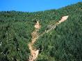 # Kaptai Lake.
Built in early sixties Kaptai Dam and the lake are the main attractions of Kaptai. If you are not visiting Kaptai separately then, don’t forget to go for a boating up to Kaptai on the Kaptai Lake while you go to Rangamati tour.
# Bandarban.

 Lots of hills and hilly areas, waterfalls, River Sangu, Lakes and the tribal culture are the main attraction of Bandarban .You can go to Bandarban from Chittagong by road. Chimbuk hill is one of the major attractions of Bandarban. You can enjoy the journey to Chimbuk Hill by jig jag hilly roads. It’s the third highest mountain in Bangladesh of approx. 3000 ft height. Reach Chimbuk by jeep or microbus from Rangamati. A beautiful Rest house is there on the top of Chimbuk hill.
If you are lucky then you can feel the clouds touching your whole body. If you take the prior permission from Roads and Highway Department you can spent a night in the rest house on the top of Chimbuk hill. If you stay there a night, you will remember your stay for your whole life with the calmness of nature hearing sometimes the wild animals squalling.
 Ruma is another hill town on the same rout of Chimbuk. If you wish to visit Ruma, then 01st go to Ruma spend some time there and then come back to Chimbuk Hill.
You can enjoy the Shailapropat a waterfall in Bandarban. Its also a tourist attraction of waterfall surrounded by hills & forest; be carefully while you go to Shailapropat - the rocky path way is very slippery, if you are not cautious there is a good chance to sleep & make an accident there.
 Another tourist spot in Bandarban is Meghla - it’s a beautiful spot where you can enjoy boat or speedboat riding on the lake Meghla. If you are lucky you may see the wild animals in the forest. There are small shades in this spot to protect you from rains in the season of monsoon and from the hit of the Sun in hot summer days. A beautiful hanging wooden bridge enhances the beauty of this spot. In one side there are some constructions and facilities for the tourists like tower, restaurant while on the other side is wild life, natural forest and hills. In the town you can visit the house where the king of tribe Chakma lives and from there you can visit the archeological museum of Bandarban. In this museum you will find the archeological history of the tribal life and the tribes of hill areas of Bandarban. The museum authority has set up various tribal houses in the museum, which will give you a brief idea of kinds of tribal houses, their design and architectural structures.
 |
| Foys lake |


 |
| Air port mosque |
 |
| Ctg air port |

 |
| cricket stadium |