Bangladesh officially the People's Republic of Bangladesh (Bangla: গণপ্রজাতন্ত্রী বাংলাদেশ Gônoprojatontri Bangladesh) is a sovereign state located in South Asia. It is bordered by India on all sides except for a small border with Burma (Myanmar) to the far southeast and by the Bay of Bengal to the south. Together with the Indian state of West Bengal, it makes up the ethno-linguistic region of Bengal. The name Bangladesh means "Country of Bengal" in the official Bengali language.
 The borders of present-day Bangladesh were established with the partition of Bengal and India in 1947, when the region became East Pakistan, part of the newly formed nation of Pakistan. However, it was separated from the western wing by 1,600 km (994 mi) of Indian territory. Due to political exclusion, ethnic and linguistic discrimination, and economic neglect by the politically-dominant West Pakistan, popular agitation grew against West Pakistan and led to the Bangladesh Liberation War in 1971, which the Bengali people won with the support of India. After independence, the new state endured famines, natural disasters and widespread poverty, as well as political turmoil and military coups. The restoration of democracy in 1991 has been followed by relative calm and economic progress.Bangladesh is a secular republic and a parliamentary democracy, with an elected parliament called the Jatiyo Sangshad. It is the eighth most populous country and among the most densely populated countries in the world. A high poverty rate prevails, although the United Nations has acclaimed Bangladesh for achieving tremendous progress in human development.Geographically, the country straddles the fertile Ganges-Brahmaputra Delta and is subject to annual monsoon floods and cyclones.The country is listed among the Next Eleven economies and Global Growth Generator countries. It is a founding member of the South Asian Association for Regional Cooperation, the D-8 and BIMSTEC, and a member of the Commonwealth of Nations, the Organisation of the Islamic Conference and the Non-Aligned Movement. However, Bangladesh continues to face a number of major challenges, including widespread political and bureaucratic corruption, economic competition relative to the world, serious overpopulation, widespread poverty, and an increasing danger of hydrologic shocks brought on by ecological vulnerability to climate change.
# History
The history of Bangladesh as a nation state began in 1971, when it seceded from Pakistan. Prior to the creation of Pakistan in 1947, modern-day Bangladesh was part of ancient, classical, medieval and colonial India.The area's early history featured a succession of Indian empires, internal squabbling, and a tussle between Hinduism and Buddhism for dominance. Islam made its first appearance during the 12th century when Sufi missionaries arrived. Later, occasional Muslim raiders reinforced the process of conversion by building mosques, madrassas and Sufi Khanqah.The borders of present-day Bangladesh were established with the partition of Bengal and India in 1947, when the region became East Pakistan, part of the newly formed Islamic State of Pakistan. However, it was separated from the western wing by 1,600 km (994 mi) of Indian territory. Due to political exclusion, ethnic and linguistic discrimination, as well as economic neglect by the politically-dominant West Pakistan, popular agitation led by Sheikh Mujibur Rahman grew against West Pakistan, resulting in the Bangladesh Liberation War of 1971, which the Bengali people won with the support of India. After independence, the new state endured famine, natural disasters and widespread poverty, as well as political turmoil and military coups. The restoration of democracy in 1991 has been followed by relative calm and economic progress.
# The Bengali Language Movement
The Bengali Language Movement, also known as the Language Movement Bhasha Andolon, was a political effort in Bangladesh (then known as East Pakistan), advocating the recognition of the Bengali language as an official language of Pakistan. Such recognition would allow Bengali to be used in government affairs.When the state of Pakistan was formed in 1947, its two regions, East Pakistan (also called East Bengal) and West Pakistan, were split along cultural, geographical, and linguistic lines. In 1948, the Government of Pakistan ordained Urdu as the sole national language, sparking extensive protests among the Bengali-speaking majority of East Pakistan. Facing rising sectarian tensions and mass discontent with the new law, the government outlawed public meetings and rallies. The students of the University of Dhaka and other political activists defied the law and organised a protest on 21 February 1952. The movement reached its climax when police killed student demonstrators on that day. The deaths provoked widespread civil unrest led by the Awami Muslim League, later renamed the Awami League. After years of conflict, the central government relented and granted official status to the Bengali language in 1956. In 2000, UNESCO declared 21 February International Mother Language Day for the whole world to celebrate,in tribute to the Language Movement and the ethno-linguistic rights of people around the world.The Language Movement catalysed the assertion of Bengali national identity in Pakistan, and became a forerunner to Bengali nationalist movements, including the 6-point movement and subsequently the Bangladesh Liberation War in 1971. In Bangladesh, 21 February is observed as Language Movement Day, a national holiday. The Shaheed Minar monument was constructed near Dhaka Medical College in memory of the movement and its victims.
# Divisions, districts and upazilas
Bangladesh is divided into seven administrative divisions,[43][44] each named after their respective divisional headquarters: Barisal (বরিশাল), Chittagong (চট্টগ্রাম), Dhaka (ঢাকা), Khulna (খুলনা), Rajshahi (রাজশাহী), Sylhet (সিলেট), and Rangpur (রংপুর).
 Divisions are subdivided into districts (zila). There are 64 districts in Bangladesh, each further subdivided into upazila (subdistricts) or thana. The area within each police station, except for those in metropolitan areas, is divided into several unions, with each union consisting of multiple villages. In the metropolitan areas, police stations are divided into wards, which are further divided into mahallas. There are no elected officials at the divisional, district or upazila levels, and the administration is composed only of government officials. Direct elections are held for each union (or ward), electing a chairperson and a number of members. In 1997, a parliamentary act was passed to reserve three seats (out of 12) in every union for female candidates.Dhaka is the capital and largest city of Bangladesh. Other major cities include Chittagong, Khulna, Rajshahi, Sylhet, Barisal, Bogra, Comilla, Mymensingh and Rangpur. These cities have mayoral elections, while other municipalities elect a chairperson. Mayors and chairpersons are elected for a span of five years.
# Geography and climate
Bangladesh lies between latitudes 20° and 27°N, and longitudes 88° and 93°E.
 Bangladesh is in the low-lying Ganges–Brahmaputra River Delta or Ganges Delta. This delta is formed by the confluence of the Ganges (local name Padma or Pôdda), Brahmaputra (Jamuna or Jomuna also known as "Yamuna"), and Meghna rivers and their respective tributaries. The Ganges unites with the Jamuna (main channel of the Brahmaputra) and later joins the Meghna to eventually empty into the Bay of Bengal. The alluvial soil deposited by these rivers has created some of the most fertile plains in the world. Bangladesh has 57 trans-boundary rivers, making water issues politically complicated to resolve – in most cases as the lower riparian state to India. Most parts of Bangladesh are less than 12 m (39.4 ft) above the sea level, and it is believed that about 10% of the land would be flooded if the sea level were to rise by 1 m (3.28 ft).
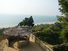
In south east Bangladesh experiments have been done since the sixties to 'build with nature'. By implementing cross dams, the natural accretion of silt has created new land. With Dutch funding, the Bangladeshi government began to help develop this new land in the late 1970s. The effort has since become a multiagency operation building roads, culverts, embankments, cyclone shelters, toilets and ponds, as well as distributing land to settlers. By fall 2010, the program will have allotted some 27,000 acres (10,927 ha) to 21,000 families.The highest point in Bangladesh is in Mowdok range at 1,052 m (3,451 ft) in the Chittagong Hill Tracts to the southeast of the country. Cox's Bazar, south of the city of Chittagong, has a beach that stretches uninterrupted over 120 kilometres (75 mi).
Straddling the Tropic of Cancer, Bangladeshi climate is tropical with a mild winter from October to March, a hot, humid summer from March to June. A warm and humid monsoon season lasts from June to October and supplies most of the country's rainfall. Natural calamities, such as floods, tropical cyclones, tornadoes, and tidal bores occur almost every year,[51] combined with the effects of deforestation, soil degradation and erosion. The cyclones of 1970 and 1991 were particularly devastating. A cyclone that struck Bangladesh in 1991 killed some 140,000 people.In September 1998, Bangladesh saw the most severe flooding in modern world history. As the Brahmaputra, the Ganges and Meghna spilt over and swallowed 300,000 houses, 9,700 kilometres (6,027 mi) of road and 2,700 kilometres (1,678 mi) of embankment 1,000 people were killed and 30 million more were made homeless with 135,000 cattle killed, 50 square kilometres (19.3 sq mi) of land destroyed and 11,000 kilometres (6,835 mi) of roads damaged or destroyed. Two-thirds of the country was underwater. There were several reasons for the severity of the flooding. Firstly, there were unusually high monsoon rains. Secondly, the Himalayas shed off an equally unusually high amount of melt water that year. Thirdly, trees that usually would have intercept rain water had been cut down for firewood or to make space for animals.Bangladesh is now widely recognized to be one of the countries most vulnerable to climate change. Natural hazards that come from increased rainfall, rising sea levels, and tropical cyclones are expected to increase as climate change, each seriously affecting agriculture, water & food security, human health and shelter. It is believed that in the coming decades the rising sea level alone will create more than 20 million climate refugees.Bangladeshi water is contaminated with arsenic frequently because of the high arsenic contents in the soil. Up to 77 million people are exposed to toxic arsenic from drinking water.Bangladesh is among the countries most prone to natural floods, tornados and cyclones.
## National symbols of Bangladesh
- Anthem Amar Shonar Bangla
- Animal Royal Bengal Tiger
- Bird Oriental Magpie Robin
- Fish Hilsa
- Flower White Water Lily
- Fruit Jack fruit
- Tree Mango Tree
- Sport Hadudu
- Calendar Bengali calendar

# Data Sources:wikipedia.org